DATES / RATES
Rates are listed per person in USD
|
| Start Date | End Date | Triple Suite |
|---|
| Jun 01, 2027 | Jun 10, 2027 | 9,695 |
Rates are listed per person in USD
|
| Start Date | End Date | (Starting from)
Triple Suite | (Mid-range)
Triple Suite | (High-end)
Triple Suite |
|---|
| Jun 01, 2027 | Jun 10, 2027 | 9,695 | 9,695 | 9,695 |
Day
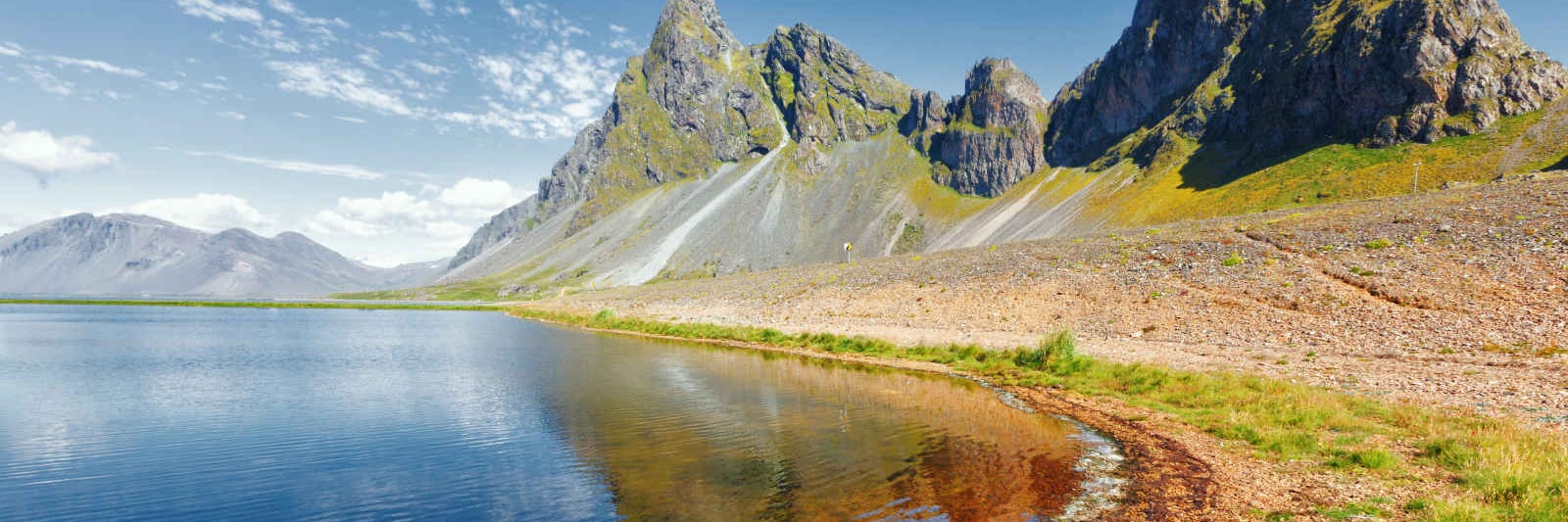
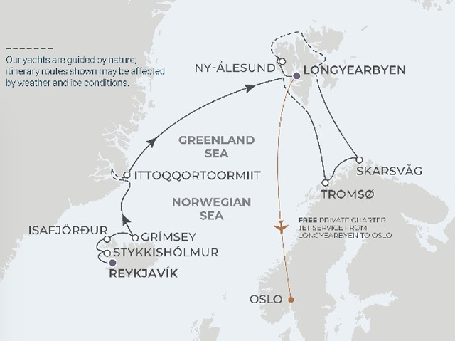
1 : Reykjavik, Iceland
In
the southwest of Iceland near Faxaflói Bay lies the capital
of the country, Reykjavík, simultaneously cosmopolitan and
charming. The colorful houses on the horizon create a quaint scene that
will make you want to stay forever. Kaleidoscopic views await you at
the Harpa Concert Hall, a glittering, glass structure that perfectly
exemplifies Iceland’s modern design and will fascinate your
inner architect. One of Iceland’s most prominent landmarks is
Perlan, originally a group of hot water tanks that was converted to a
building that now hosts an exhibition, planetarium, restaurant and
observation deck, located atop Öskjuhlíð
hill.
Day
2 : Stykkishólmur, Iceland
Journey
into a world where ancient sagas and modern marvels converge. Welcome
to Stykkishólmur, a charming coastal town nestled near the
Snaefellsnes Peninsula. Your adventure brings you to the heart of
Icelandic culture, breathtaking landscapes, and exhilarating
explorations. As your yacht docks in Stykkishólmur, feast
your eyes on the vivid palette of houses and boats that create a
picturesque harbor scene. Just a short distance away lies the mystical
Snaefellsjökull National Park, home to the iconic
glacier-capped volcano that inspired Jules Verne’s Journey to
the Center of the Earth. Climb to the top of Súgandisey
Island for panoramic views of Breidafjordur Bay, dotted with countless
islets. Immerse yourself in tales of Vikings and mythical beings at
community museums. Savor unique Icelandic dishes at local restaurants,
such as creamy lobster soup, freshly caught fish, and traditional rye
bread baked using geothermal heat. Embrace the warmth of the welcoming
locals and let their stories weave into the tapestry of your journey.
Day
3 : Isafjörður, Iceland
Amid
the enchanting Westfjords of Iceland stands
Ísafjörður, a fishing town thriving with
local energy and culture. Summer months here are brisk, but
it’s this cool climate combined with breathtaking and quaint
scenery that makes the village feel like an undiscovered treasure. The
massive depression among the flat-topped mountains called Naustahvilft
- known colloquially as the troll seat - combines Iceland’s
natural beauty with the town’s rich folklore. Make a stop at
Dokkan Brugghús, the only brewery in the entire Westfjords,
and sample the local beers, crafted with naturally filtered spring
water from the nearby mountains. For those for whom the sea’s
siren call beckons, you must visit the Westfjord History Museum, based
on Ísafjörður’s maritime heritage
and its rise in the fishing industry.
Day
4 : Grímsey Island, Iceland
Home
to about 100 people — the northernmost inhabited island in
Iceland — and one million birds, Grímsey Island is
a treasure in the Arctic Circle. The residents enjoy 24 hours of sun
throughout the summer, as do the Puffins. Look for the stone sphere
marking the edge of the Arctic Circle. Its design makes it easier to
move as the Arctic Circle moves, always keeping the true demarcation.
Grímsey Island is a birdwatcher’s paradise, filled
with various species, including razorbills, kittiwakes, auks and
thick-billed murres. Amid the breathtaking landscapes are the
island’s basalt columns. These geometric geological
structures covered in lush moss dip into the water, creating a
mesmerizing scene.
Day
5 : Fjords of Greenland — Captain’s Choice
A
once-in-a-lifetime adventure is yours to have on the largest island in
the world, Greenland. At the very top of the world, it’s
renowned for its vast tundra, immense glaciers and deep fjords. From an
aerial view, the systems link together like the roots of a massive tree
and stretching coastlines are dotted with small islands. Landscapes
include enormous icebergs and glaciers. Depending on the time of year,
you may see polar bears hunt on the ice.
CAPTAIN’S
CHOICE - Your
Captain will expertly navigate ice floes, icebergs and changing sea and
weather conditions to ensure you experience the most from your
expedition. Each day is a new adventure filled with a spontaneous sense
of exploration as your Captain works with our expedition team to
determine possible shore landings and Zodiac safaris. All itinerary
routes serve as examples and are subject to change based on current
conditions, prioritizing the safety and optimal expedition experience
for all guests.
Day
6 : Ittoqqortoormiit, Greenland
The
name "Ittoqqortoormiit" means "Big-House Dwellers" in the Eastern
Greenlandic dialect. Very few visitors make the trek here, as the
winters are long, and the sea is frozen for nine months of the year.
Ittoqqortoormiit is located at Scoresby Sound and with its side fjord
is the largest fjord complex in the world, as well as the
world’s longest fjord. Within its borders is the tallest
mountain in the Arctic region, the two-mile-tall Gunnbjorn Mountain.
During early spring, when the sea ice is still thick, yet the sun is
high in the sky, many of the local people go out for a weekend on dog
sledding trips.
Day
7 : At Sea
Spend
the day on the high seas pampering yourself at the spa or enjoying some
time on deck. Mingle with your fellow explorers and swap stories of
your exploits, making plans for new ones together once you get to shore
Day
8 : Exploring Svalbard - Captain’s Choice
Even
in one of the most isolated regions of the Arctic, there is still the
captivating history of a pioneering past. Our expedition leaders, along
with the captain and onboard pilot, will determine possible landings
each day for all-out explorations. Wildlife abounds throughout the
archipelago of Svalbard, such as puffins, reindeer, Arctic terns and
foxes. An expert photographer will help you look out for the perfect
photo opportunity of these animals, but especially for the elusive
polar bear. As Zodiac cruises may bring you closer to glaciers, keep
your eyes on the water for whale fins.
CAPTAIN’S
CHOICE - Your
Captain will expertly navigate ice floes, icebergs and changing sea and
weather conditions to ensure you experience the most from your
expedition. Each day is a new adventure filled with a spontaneous sense
of exploration as your Captain works with our expedition team to
determine possible shore landings and Zodiac safaris. All itinerary
routes serve as examples and are subject to change based on current
conditions, prioritizing the safety and optimal expedition experience
for all guests.
Day
9 : At Sea
Spend
the day on the high seas pampering yourself at the spa or enjoying some
time on deck. Mingle with your fellow explorers and swap stories of
your exploits, making plans for new ones together once you get to shore
Day
10 : Tromsø, Norway
Not
only will you witness magnificent fjords and glaciers throughout
Tromsø, Norway, but you will also immerse yourself in a
sophisticated cultural life and architectural delights. A superb
example of blending the built environment with the natural setting is
the Arctic Cathedral, an architectural marvel made up of
aluminum-coated concrete panels, making it a stunning façade
resembling an iceberg. To see the real icebergs, all you have to do is
take the Fjellheisen cable car 1,525 feet above sea level for
incredible views of the Norwegian fjords. You can also stroll around
the Arctic-Alpine Botanical Garden, visit the Science Centre of
Northern Norway or gain new knowledge at the city’s museums
including the Polar Museum, Tromsø University Museum, and
Perspektivet Museum.
Day
11 : Skarsvåg (North Cape), Norway
This
village in North Cape on the island of Magerøya claims the
distinction of being the northernmost fishing village in the world.
Rolling hills of green, magnificent arctic fjords and an untamed
natural beauty make it a stunning stop off the beaten path. Rugged
cliffs are home to thousands of cormorants, puffins and gannets. While
there are few people who inhabit the village, you are likely to come
across wild reindeer that may venture close to town. Within the village
of Skarsvåg sits the Christmas and Winter House, a cozy
visitors’ attraction where you can experience the holiday
year-round with a hot drink and slice of cake as you peruse the local
wares and handicrafts and enjoy an atmosphere of dazzling decorations
and festive music.
Day
12 : Exploring Svalbard - Captain’s Choice
Even
in one of the most isolated regions of the Arctic, there is still the
captivating history of a pioneering past. Our expedition leaders, along
with the captain and onboard pilot, will determine possible landings
each day for all-out explorations. Wildlife abounds throughout the
archipelago of Svalbard, such as puffins, reindeer, Arctic terns and
foxes. An expert photographer will help you look out for the perfect
photo opportunity of these animals, but especially for the elusive
polar bear. As Zodiac cruises may bring you closer to glaciers, keep
your eyes on the water for whale fins.
CAPTAIN’S
CHOICE - Your
Captain will expertly navigate ice floes, icebergs and changing sea and
weather conditions to ensure you experience the most from your
expedition. Each day is a new adventure filled with a spontaneous sense
of exploration as your Captain works with our expedition team to
determine possible shore landings and Zodiac safaris. All itinerary
routes serve as examples and are subject to change based on current
conditions, prioritizing the safety and optimal expedition experience
for all guests.
Day
13 : At Sea
Spend
the day on the high seas pampering yourself at the spa or enjoying some
time on deck. Mingle with your fellow explorers and swap stories of
your exploits, making plans for new ones together once you get to shore
Day
14 : Exploring Svalbard - Captain’s Choice
Even
in one of the most isolated regions of the Arctic, there is still the
captivating history of a pioneering past. Our expedition leaders, along
with the captain and onboard pilot, will determine possible landings
each day for all-out explorations. Wildlife abounds throughout the
archipelago of Svalbard, such as puffins, reindeer, Arctic terns and
foxes. An expert photographer will help you look out for the perfect
photo opportunity of these animals, but especially for the elusive
polar bear. As Zodiac cruises may bring you closer to glaciers, keep
your eyes on the water for whale fins.
CAPTAIN’S
CHOICE - Your
Captain will expertly navigate ice floes, icebergs and changing sea and
weather conditions to ensure you experience the most from your
expedition. Each day is a new adventure filled with a spontaneous sense
of exploration as your Captain works with our expedition team to
determine possible shore landings and Zodiac safaris. All itinerary
routes serve as examples and are subject to change based on current
conditions, prioritizing the safety and optimal expedition experience
for all guests.
Day
15 : Ny-Ålesund (Svalbard), Norway
Ny-Ålesund
is the northernmost settlement on Svalbard with a population of about
12 people. Here you can find an international scientific research
station. Close to the village is a breeding ground for rare geese and
arctic terns. Not far from here you may cruise your way toward the
Ossian Sars Nature Reserve, a preservation of mountains and surrounding
vegetation that is a sight to behold.
Day
16 : Longyearbyen (Svalbard), Norway
Longyearbyen
is in a valley on the shores of the idyllic Adventfjord, surrounded by
steep mountains and several glaciers. There are only around 25 miles of
roads in this village, which is divided into several neighborhoods,
including the town center and Nybyen (New Town), which consists of
charming miners’ barracks constructed after the war, as well
as guest houses, a restaurant and gallery, and not to mention beautiful
views of the landmark mountain, Hiorthfjellet. Be sure to visit the
Svalbard museum as a break between the plethora of activities like
summer dogsledding or cruising to the abandoned Russian city of
Pyramiden
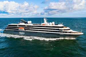
World Voyager (Luxury Expedition, 198-guests)
Experience extraordinary Antarctica to the fullest and in the shortest amount of time aboard our newest yacht, World Voyager. Our NEW Drake Express option lets you fly straight into King George Island off the coast of Antarctica and over the Drake Passage both ways to maximize your boots on the ground exploration time. Or spend more time exploring the Antarctica Peninsula by flying over the Drake Passage one way and still lay claim to the iconic experience of sailing the other direction with our NEW Drake Fly & Sail options.
 (Click image to view Ship details)
WHAT'S INCLUDED
- FREE cultural immersion
- FREE gourmet dining with ever-changing menus
- FREE unlimited beverages, including fine wines, spirits and
craft beers
- FREE open bars and lounges, including 24-hour bar service
with specialty canapés
- FREE stocked in-room minibar
- FREE specialty coffees, teas and fresh-pressed juices
- FREE afternoon and high tea
- FREE champagne and gourmet canapés during meet
and greet
- FREE 24-hour room service, including spirits, wine and beer
- FREE L'OCCITANE bath amenities
- FREE pre-paid gratuities
- FREE use of walking sticks and binoculars
- FREE reusable water bottle
- FREE butler service and expanded room service menu in suites
- Government Taxes and Fees per guest are included in Cruise
Fares.
- Trip delay and medical evacuation coverage included at no
additional cost.
Exclusively
on Polar Expeditions
- FREE cultural immersion
- FREE private charter jet service with private group
transfers*
- FREE enrichment lectures and destination briefings
- FREE shore landings led by expert field guides
- FREE escorted sightseeing safaris by Zodiac
- FREE polar plunge
- FREE Atlas Ocean Voyages parka and vest
- FREE use of knee boots
- FREE 1-night pre-cruise hotel stay*
- FREE 1-night post-cruise hotel stay on select Antarctica
expeditions