HIGHLIGHTS
- Zodiac
cruise into grottos, narrow channels and beneath vertical cliffs. A
clifftop walk to view nesting birds such as puffins, guillemots and
fulmars in the Faroe Islands
- Discover
the rich history in Kirkwall including a visit to Skara Brae, a unique
and well-preserved 5,000-year-old semi-subterranean village
- Join
a group of the rare few to visit remote Jan Mayen Island, home to Mount
Beerenberg, the world’s northernmost active volcano
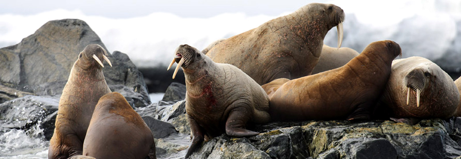
- Photograph
walrus and reindeer while keeping an eye out for the Arctic’s
top predator, the beguiling polar bear, hunting for seals in the pack
ice
- Kayak
along some of the many glaciers streaming into the deep fjords in the
northwest coast of Spitsbergen (additional cost)
DATES / RATES
Rates are listed per person in USD
|
| Start Date | End Date | Stateroom Triple | Stateroom Twin | Balcony Stateroom C | Balcony Stateroom B | Balcony Stateroom A | Balcony Suite | Junior Suite | Captains Suite |
|---|
Rates are listed per person in USD
|
| Start Date | End Date | (Starting from)
Stateroom Triple | (Mid-range)
Balcony Stateroom A | (High-end)
Captains Suite |
|---|
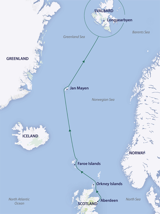
ITINERARY
Day
1 – Aberdeen, embark Greg Mortimer
Make
your own way to Aberdeen pier. Our expedition team will welcome you
aboard the Greg Mortimer at approximately 4.00 pm (boarding time will
be confirmed in your final documents). You'll have time to settle into
your cabin before our important briefings. After settling in we will
set sail in for the Orkney Islands, where Stone Age villages like Skara
Brae, relics of Viking occupation and the wild sea vie for our
attention.
Day
2 – Kirkwall, Orkneys
Discover
the rich history in Kirkwall, capital of the Orkney Islands. Initial
impressions are misleading, as the harbour area looks modern, but the
narrow winding streets and lanes of the old town, which have remained
relatively unchanged over the centuries are appealing. Explore
magnificent St Magnus Cathedral built from red and white sandstone and
considered the finest medieval building in the north of Scotland before
popping across the road to Tankerness House and Gardens, a restored
16th century former manse, now housing the Orkney Museum featuring
archaeological artefacts from Neolithic times to the Vikings. The
exhibition is a great way to whet your appetite for the archaeological
gems you will find on the mainland including the unique and
well-preserved 5,000-year-old semi-subterranean village of Skara Brae.
Everything
west of Kirkwall is known as West Mainland, an area of rich farmland,
rolling hills and moorland, with dramatic cliffs along the Atlantic
coastline. Some of the main archaeological attractions we may see
include the standing Stones of Stenness, the Ring of Brodgar, and the
chambered tombs of Maes Howes that to this day still have unresolved
mysteries. One of the mainland's main attractions is Skara Brae, the
best-preserved Stone Age village in northern Europe, located in the
spectacular white sands of the Bay of Skaill. Revealed in 1850 after a
storm blew away the dunes, the site dates from approximately 5,000
years ago and was occupied for about 600 years, showing a unique
picture of the lifestyle of the original inhabitants.
Days
3-5 – Faroe Islands
In
the middle of the North Atlantic, barely visible on most world maps,
you will find the Faroe Islands, an archipelago consisting of 18
islands with a population of only 50,000. The Faroe Islands are built
up of layers of volcanic basalt, and are tilted with the eastern shores
sloping into the sea and the western coasts rising up in soaring and
spectacular cliffs. With their breathtaking beauty, steep mountains
covered in soft green grass, deep fjords, long summer nights, unique
culture, and a humble, friendly and welcoming people, the islands are
the perfect destination for travellers wanting something dramatically
different from the mainstream.
Discover
a few of the gems of the Faroe Islands including Tórshavn,
Kirkjubour, Mykines and Vestmanner. In Torshavn, possibly the smallest
capital in the world, wander the narrow streets of this windswept town,
built on a hillside with colourful contemporary houses and old
traditional timber dwellings all painted red and with characteristic
grass roofs, white-framed windows and black wood. You may see the
oddest array of sheep lining the steep hillsides - black ones, brown
ones and even piebald ones! Perhaps catch a glimpse of Faroese ponies
with their spectacular flaxen manes and coats varying from a palomino
colour to rich chestnut. The town's history can be traced back to
around 900 AD when the first Viking settlers arrived here by longboat
from Norway.
Landing
at Mykines can be tricky. The cliffs are sheer and there are steps to
climb once you are out of the Zodiac, but the views are impressive.
Geographically, Mykines is the Faroe's most westerly outpost, and the
island dubbed the “paradise of birds” featuring
gannets, kittiwakes, fulmars, guillemots and puffins. We are able to
get quite close to the birds by sailing under the majestic bird cliffs
or on a hike. In addition to the seabirds, the Faroe Islands' remote
location functions virtually as a magnet for birds that migrate over
the North Atlantic Ocean. Around 300 bird species have been recorded in
the Faroe Islands, but only around 100 species are regular migrants or
breeding birds. This means that about 200 species are rare migrants and
new birds are added to the national list every year.
One
of the highlights in the Faroe Islands is Vestmanna Birdcliffs, where
in kayaks and Zodiacs you can explore caves, arches, waterfalls and sea
stacks below majestic cliffs towering hundreds of metres above. You may
see kittiwakes and fulmars overhead, with razorbills and guillemots
sitting on nests high above us and puffins bobbing in the sea.
Days
6-7 – Sea Crossing to Jan Mayen
Enjoy
sailing to Jan Mayen Island accompanied by sea birds while keeping a
look out for whales. Enjoy a presentation from our team of experts, get
to know your fellow expeditioners, stay fit at the gym or treat
yourself to a massage in the wellness centre.
Day
8 – Jan Mayen
The
approach to Jan Mayen is spectacular. The huge Beerenberg volcano
(2,277 metres/ 7,470 feet altitude) is the world's northernmost active
volcano, and last erupted in 1985. The northern part of the island is a
great place to look for whales and dolphins, and contains impressive
glaciers, some of which reach the sea. If the weather is friendly, we
will try to land at Kvalrossbukta, a relatively sheltered bay on the
island's west coast. This is one of the landings used to supply the
weather station Olonkinbyen, situated on the eastern side of the
island. We hope to land on front of the Norwegian station at
Olonkinbyen, stop to visit the weather station before embarking on a
three-hour hike (weather permitting) to the other side of the Island
where the Greg Mortimer will be waiting for us in Kvalrossbukta, and
our trusty Zodiacs will transport us back to the ship.
Days
9-10 – Sea Crossing to Svalbard
The
sea around Jan Mayen offers excellent whale-watching opportunities
(bottlenose, fin, and perhaps bowhead whales in the pack ice). Sail
towards Svalbard, searching for the ice edge as we continue north,
retracing the route of Dutch explorer Willem Barents who discovered
Spitsbergen and the Barents Sea, named after him. You may see harp seal
pups on the pack ice growing quickly, while their mothers hunt for
food. As we approach Svalbard, all eyes will be focused on spotting
polar bears in the pack ice.
Days
11-14 – Northern Svalbard
Over
the next three days, the Svalbard Archipelago is ours to explore. Our
experienced expedition team, who have made countless journeys to this
area, will use their expertise to design our voyage from day to day.
This allows us to make best use of the prevailing weather, ice
conditions and wildlife opportunities. Because we are so far north we
will experience nearly 24 hours of daylight and the days can be as busy
as you wish. We will generally make landings or Zodiac excursions a few
times a day; cruising along spectacular ice cliffs, following whales
that are feeding near the surface, making landings for hikes.
There
are many exciting places we can choose to visit; a sample of some of
the places where your expedition leader may choose to land, hike,
photograph or view spectacular wildlife and scenery include:
Isfjorden
Alkhornet,
at the northern entrance of Isfjorden, is a striking landmark. The
landscape around this large bird cliff is lush and beautiful. East of
Alkhornet you can find a deep and several kilometre long bay with an
exciting and diverse history. Here you will find important and
vulnerable cultural remains dating from several of Svalbard's
historical periods. Alkhornet and Trygghamna offer visitors an
interesting combination of cultural history and natural environment.
The name Trygghamna is derived from the old Dutch name Behouden Haven
and the English Safe Harbour or Safe Haven, all with the same meaning.
The name reflects on the West European whaling that was carried out
around Svalbard in the 17th century when whales would swim into the
fjords and subsequently be caught. Trygghamna was, and still is, the
perfect harbour with good anchorage. Because of its favourable
geographical position, this harbour was early known and continuously in
use.
At
Alkhornet, reindeer observations are common, there are several fox
dens, geese nest on rocks and higher up, and the bird cliff is loaded
with Brünnich's guillemots in hundreds of thousands. The cliff
also houses a large colony of kittiwakes. Often seen is the glaucous
gull patrolling the air around the cliff for potential prey. Arctic
skuas nest here as well. The moss tundra below the cliffs bear witness
of constant influx of fertilisers and some areas are extraordinarily
lush for this reason.
Kongsfjorden
(Kings Bay)
Kongsfjorden
and the surrounding country are known to be one of the most beautiful
fjord areas in Svalbard. The fjord is headed by two giant glaciers,
Kronebreen and Kongsvegen. Hike on the lush tundra amongst the summer
flowers and observe the remarkable bird cliffs near the 14th July
Glacier, where even a few puffins nest between the cracks in the cliffs.
In
this area we find the former mining settlement of Ny-Ålesund.
Situated at 78º 55' N, Ny-Ålesund is one of the
world's northern-most year-round communities. The settlement of
Ny-Ålesund is strongly linked to coal mining operations,
scientific expeditions and recently also to various international
research efforts. It is located more than 100 km north of Longyearbyen
and is one of the northernmost settlements in the world. In and around
Ny-Ålesund is found the largest concentration of protected
buildings, cultural monuments and various remains in Svalbard,
rendering the place an important cultural heritage site. The cultural
history is represented by the town itself, including 30 listed
buildings (out of 60 in total), industrial monuments related to the
coal mining operations, Roald Amundsen's airship mooring mast and
hangar foundation and some remains of research activities.
Ny-Ålesund is the largest Norwegian settlement in Svalbard
that was not set fire to during World War II. The settlement is well
preserved and worth experiencing, and serves as a valuable historical
source.
Ny-Ålesund
has also been the starting point of several historical attempts to
reach the North Pole. Names like Amundsen, Ellsworth and Nobile are
strongly linked to Ny-Ålesund. The place has been a centre
for tourist operations, with several hotels located in town. Today,
approximately 20,000 travellers visit Ny-Ålesund on a yearly
basis. Since 1964, Ny-Ålesund has also been a centre for
international Arctic research and environmental monitoring. A number of
countries run their own national research stations here, and research
activity is high in the summer.
The
islands and islets in the inner part of Kongsfjorden teem with birds.
At the head of the fjord, mighty glaciers calve into the sea. All of
this is framed by characteristic mountain formations. Situated at the
north side of the fjord, London is a monument to past optimistic
expectations for big money from the supply of marble to the world
market. Further north-west lies Krossfjorden, with its cultural remains
from the whaling period, Russian and Norwegian overwinterings and World
War II. Large bird cliffs are also found here.
Nordvesthjørnet
and Raudfjorden
It
was here, in the far north-west, that Willem Barentsz and his crew
discovered new land on 17 June, 1596. They described the land as being
“rugged for the most part, and steep, mostly mountains and
jagged peaks, from which we gave it the name of Spitsbergen”.
In the centuries that followed, the large number of bowhead whales
found here attracted whalers from the Netherlands and various other
countries, and the area became a place of high activity, both on the
shore and in the surrounding sea. This is why
Nordvesthjørnet offers the largest concentration of graves,
blubber ovens and other cultural treasures on Spitsbergen, all dating
back to this first era of the exploitation of Svalbard's natural
resources.
Magdalenefjorden
Cruise
northwards along the west coast of Spitsbergen, visiting intriguing
places like Magdalenefjorden, located inside the Northwest Spitsbergen
National Park. According to historical sources, Magdalenefjorden was
first used by the English in the early days of the whaling era. They
erected a land station on the headland and named the area Trinity
Harbour. The station was closed in 1623, but the cemetery remained in
use. More tourists are visiting Gravneset than any other site in
Svalbard outside the settlements, but since 2015, ships carrying heavy
fuel on board are no longer permitted to enter the large national parks
and nature reserves in Svalbard.
The
spectacular alpine scenery is lined with jagged mountain peaks, to
which Spitsbergen (‘pointed mountains') owes its name. At
1,115 metres / 3,658 feet, Hornemanntoppen is the highest mountain in
the area is, located east of Magdalenefjorden. The topography of the
area is mostly rocky, shorelines are covered with stones and walking
here can be challenging. The topography also does not allow for much
vegetation, which is limited to mosses and lichens near bird colonies.
Little auks are breeding in large numbers in scree slopes everywhere
around Magdalenefjorden. Amazingly, a few reindeer occasionally roam
around on mossy slopes and polar bears as well as walrus are regularly
seen here.
Smeerenberg
The
name “Smeerenburg” means “Blubber
Town”. Its whaling station served as the main base for Dutch
whaling in the first half of the 17th century, which was the period
when whale hunting was still happening along the coastline and in the
fjords of Svalbard. Smeerenburg is situated on the island of
Amsterdamøya, surrounded by fjords, tall glacier fronts and
steep, rugged mountains. The most obvious sign of its days as a whaling
station are the large cement-like remains of blubber from ovens where
the blubber was boiled. The rest of the old Smeerenburg has largely
disappeared under layers of sand.
Virgohamna
is one of Svalbard's most important cultural heritage sites. On the
beach are remains of blubber ovens and a Dutch whaling station. There
are also graves from the whaling period. But Virgohamna is most famous
for being the starting place of many an expedition attempting to reach
the North Pole. Both Andrée (1896, 1897) and Wellman (1906,
1907, 1909) built bases here, consisting of a balloon shed, airship
hangars and gas production works. The place was named after
Andrée's steamship and transport vessel, the Virgo. All the
areas with cultural remains in Virgohamna are protected. To disembark
here, one must have written permission from the Governor of Svalbard.
Ytre
Norskøya is situated in the middle of what used to be the
Dutch whaling area in the early 1600s, when it all revolved around
land-based stations for boiling the whale blubber. The station is
situated by the sound Norskøysundet, between the islands of
Ytre Norskøya and Indre Norskøya. A sheltered bay
offers protection against the weather and a broad beach facilitates
landings. Today, the remains of nine blubber ovens lie in a line along
the beach in the bay. The area with 165 graves on the island is one of
the largest burial grounds in Svalbard.
Woodfjorden,
Liefdefjorden and Bockfjorden
Located
along the north coast, Woodfjorden, Liefdefjorden and Bockfjorden are
rarely-visited places. This is the land of contrasts. By the large,
flat Reinsdyrflya there is a great fjord system that stretches towards
several mountain ridges of varying shapes and ages, including alpine
summits of very old granite, majestic red mountains of Devonian
sandstone, cone-shaped remnants of three volcanoes and even hot
springs. Large glacier fronts calve in the sea, while polar bears are
busy hunting for ringed seals and sweeping the islets for birds' eggs.
Walk on smooth raised beach terraces to a superb viewpoint or hike in
the mountains on the tundra where pretty brightly coloured wildflowers
and lichen grow and where reindeer graze. We may visit trapper huts of
yesteryear where Russians Pomors would hunt and survive the cold harsh
winters, all while remaining alert for wandering polar bears and their
cubs.
Moffen
Island
Moffen
Island is situated directly north of 80°N. After the
near-extinction of walrus in Svalbard in the middle of the 20th
century, Moffen Island played an important role in re-establishing the
species here, a process which is still going on. Today, there are often
larger numbers of walrus hauled out at the southern tip of the island.
This is the reason why Moffen is protected. Approach during the summer
(15th May to 15th September) is limited to a minimum distance of 500
metres / 1,640 feet.
Sjuøyane
(Seven Islands)
In
the very north of Svalbard, in the ocean north of Nordaustlandet, is
the little archipelago of Sjuøyane (the seven islands), with
its characteristically hat-shaped mountains. The hard granite mountains
have acquired a green covering of moss due to thousands of breeding
seabirds. Walrus dive for clams in the waters between the islands and
in the bays. Most of the islands have been named after the English
North Pole expeditions led by Phipps (1773) and Parry (1827).
Sjuøyane
are located at about 80°45?N. The mountains, of gneiss and
granites, are tied together by plains created by deposits, which have
given the islands their large, semi-circular bays. In general the
sparse vegetation belongs to the Arctic polar desert zone. However,
fertilisation by bird droppings provide a breeding ground for mosses
and scurvygrass (Cochlearia groenlandica), which give some of the
mountains their characteristic greenish colour.
When
the ice breaks up around Sjuøyane and the first seabirds
return in April–May, the islands wake again after a long
winter, during which the only wildlife is the odd polar bear, arctic
fox, reindeer and walrus. There is a large number of bird cliffs in
Sjuøyane, scattered around most of the islands. Little auks
come in the largest numbers, but there are also several smaller
colonies of puffins and Brünnich's guillemots. Common
guillemots nest scattered around the islands. One of the few known
colonies of ivory gulls can be found on Phippsøya. Ivory
gulls are categorised as listed as a Near Threatened Species.
There
are also several haul-out sites for walrus on Sjuøyane. The
most reliable place to encounter them is Isflakbukta on the island of
Phippsøya. Up to 100 animals can be seen on the beach, and
normally walrus are very active in the shallow bay.
Polar
bears can be seen anywhere on Sjuøyane. The polar bear
distribution is strongly related to the distribution of sea ice. If
there is drift ice around the islands it is more likely that there will
be polar bears on the islands. Usually there are also a few polar bears
remaining in the area over the summer. Reindeer and arctic fox are also
found on Sjuøyane.
Day
15 – Longyearbyen
During
the early morning we cruise into Longyearbyen. Farewell your expedition
team, crew and fellow expeditioners as we all continue our onward
journeys. Enjoy a town tour of Longyearbyen before an onward transfer
to the airport in the afternoon.
Greg Mortimer (Luxury Expedition, 120-guests)
Capable of negotiating the strongest winds and waves, the Greg Mortimer is built to world-class polar standards. It is designed in close consultation with expedition specialists, taking advantage of Auroras more than 25 years of experience.
 (Click image to view Ship details)
WHAT'S INCLUDED
- Half
day city tour in Longyearbyen upon disembarkation followed by a
transfer to the airport on Day 15
- Onboard
accommodation during voyage including daily cabin service
- All
meals, snacks, tea and coffee during voyage
- Beer,
house wine and soft drinks with dinner
- Captain’s
Welcome and Farewell reception including four-course dinner, house
cocktails, house beer and wine, non-alcoholic beverages
- All
shore excursions and Zodiac cruises
- Educational
lectures and guiding services from expedition team
- Free
access to our onboard doctor for consultations relating to
sea-sickness. A standard fee of US $60.00 (reclaimable through your
travel insurance provider) applies for medical consultations not
related to sea-sickness
- A
3-in-1 waterproof polar expedition jacket
- Complimentary
use of muck boots during the voyage
- Comprehensive
pre-departure information
- A
printed photo book produced with photos from your voyage
- Port
surcharges, permits, and landing fees
OPTIONAL ACTIVITIES
ADVENTURE
OPTIONS
- Photography:
FREE
- Kayaking:
USD 1,190 per person